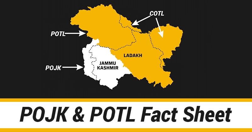
Let’s understand POJK, POTL and COTL– The illegal occupation of Pakistan and China
21 Feb 2020 22:25:03

As Jammu and Kashmir got bifurcated on 31st Oct 2019, India got two new Union Territories in J&K and Ladakh. The major move by the Govt. of India gave the erstwhile state of J&K its new identity which was once spread over the area of 2,22,236 sq km in total. However, after several conspiracies and invasions of Pakistan it got restricted to 1,01,000 sq km, rest of the territory being under illegal occupation of Pakistan and China. These illegally occupied areas are known as POJK, POTL and COTL today.
While Pakistan occupied Jammu Kashmir (POJK) comprises of Mirpur Muzzafarabad from Jammu and Kashmir region covering an area of 13,297 sq km. Pakistan Occupied territories of Ladakh (POTL) comprises of Gilgit and Baltistan and total area of POTL is around 64817 sq km.
China Occupied territories of Ladakh (COTL) comprises of Aksai Chin and Shaksgam Valley. Total Area of the territory under Chinese occupation is approx.37,555 Sq km. In addition to this, about 5,180 Sq. Km. of J&K was provisionally ceded to China by Pakistan under the March 1963 Sino-Pak Boundary agreement which is Shakasgam valley. The region Aksai Chin is scarcely populated area. Line of Actual Control is neither delineated nor demarcated.
Economic Exploitation of Pakistan Occupied territories of Ladakh (POTL)
It’s a known fact that Gilgit Baltistan has huge reserve of Gold deposit. According to a joint report prepared by Australian Agency for International Development and Pakistani Miner Development in 1995, there are 1480 gold mines in this area, out of which 123 have ore, where the gold content is many times higher than the world famous mines of south Africa. Pak Government was planning to exploit these Gold mines with the help of AUAID. As per the agreement AUAID will get 54% share and PMDC will get 23 % share and remaining 23 % will go to Pakistan Government names Ministry of Kashmir and Northern Areas Affairs (Kana). The locals who own the mines would get nothing.
The data available not only exposes Pakistan’s ugly intentions but also uncovers its hidden motives. Not only Gold mines but Pakistan also intends to build mega dams Skardu and Bhasha, which will inundate millions of acres of populated fertile land to provide cheap electricity to the rest of Pakistan.
Atrocious and mixed strategies of Pakistan and China
Gilgit and Baltistan link Pakistan to China. Karakoram Highway is the road link between Pakistan and China. Almost 857km long highway was constructed without paying a single penny to the local people and on the other hand it led to the ceding of 2500 sq miles of Shaksgam valley to China, illegally, apparently to get Chinese assistance to build this highway.
China wants to link up Gwadar to Gilgit and has constructed a dry port at Sust 140 Km north to Gilgit which was inaugurated by General Musharraf on July 4, 2006. It now intends to realign the Karakoram Highway which will enable it to access the port to facilitate exports from Chinese factories located in North west China. Pakistan earns billions of dollars from Highway. Besides, military equipment from China comes via Karakoram Highway, but no royalty is paid to the locals.
Funds earmarked for developmental schemes often lapse. This region has the highest peaks in the world apart from Mt Everest & Kanchenjunga. It has 3 Longest Glaciers outside polar region. 5000 Sq. km Deosai Plateau at the altitude of 4115 m, which is second highest plateau in the world.