16 September 1842, Treaty of Chushul; History of Dogra–Tibetan War
| 16-Sep-2020 |

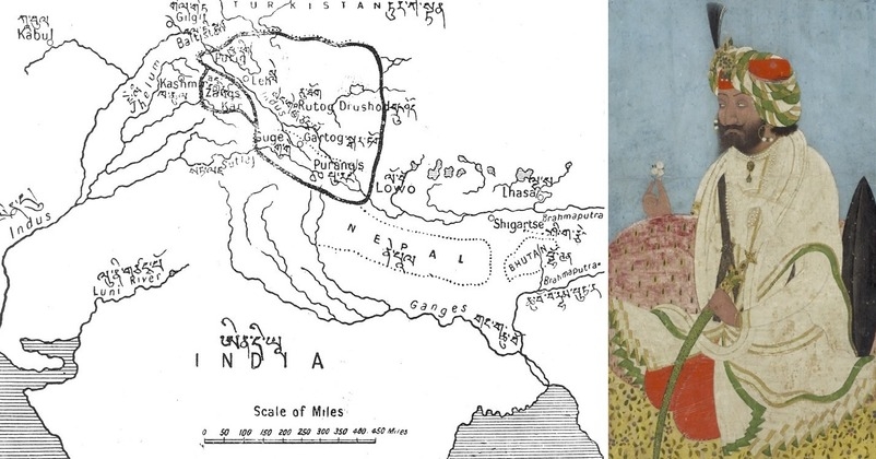
Gulab Singh of the Dogra dynasty, as Raja of Jammu and Kashmir attained heights of power and splendour that shaped the destiny of the region and added glorious chapter to the history of J&K. The Dogra-Tibetan war started from May 1841 between the forces of the Dogra king Gulab Singh, under the suzerainty of the Sikh Empire, and Tibet under the suzerainty of Qing China and came to an end with the 'Treaty of Chushul' that was signed on this day in August 1842. Raja Gulab Singh's commander, the able general Zorawar Singh Kahluria, after the conquest of Ladakh, attempted to extend its boundaries in order to control the trade routes into Ladakh. Zorawar Singh's expedition due to the effects of inclement weather, suffered a defeat at Minsar (or Missar) and Singh was killed. The Tibetans then advanced on Ladakh. Raja Gulab Singh sent reinforcements under the command of his nephew Jawahir Singh and a subsequent battle near Leh in 1842 led to a Tibetan defeat. The “Treaty of Chushul” was signed this day in Aug 1842 maintaining the status quo antebellum.
The ambitious but cautious Gulab Singh took approval of the Lahore Durbar for his challenging campaigns in the snowbound mountains with Ladakh as his first target. He had realised that the occupation of the Himalayan kingdom would not only give him the monopoly over Leh’s flourishing entrepot frequented by merchants from Tibet, Sinkiang (Xinjiang) and Kashmir but also the control over an important route between Tibet and Kashmir, which was used for the lucrative pashmina trade. This project began in 1834 under the command of his most trusted and intrepid Dogra General Zorawar Singh. It claimed thousands of lives, including that of the general during the Lhasa campaign in 1842. In 1841, the present-day battalion of the 4th J&K Rifles, then commanded by Gen Zorawar Singh, captured Mantalai standard, the flag of the Chinese Imperial Army in a battle in Tibet. It is still in possession of the JAK Rifles. Eventually, with the general killed and the army annihilated, the biting winter and snow halted the march of the Jammu force towards Tibet.
Statue of General Jorawar Singh in Jammu
Treaty of Chushul
The Tibetans and the Imperial Court of China, on the other hand, too, realized the futility of waging a war in this extreme end of their empire at a time when it was facing a greater threat in this form. As a result, both the parties entered into a treaty signed at Chushul in 1842. It was agreed that the traditional boundary between Tibet and Ladakh would be respected and trade would follow the traditional route between Lhasa and Leh, opening up new trade interests for the Jammu kingdom. For the next 120 years, that's where the boundaries of Ladakh remained, notwithstanding the fact that the border regions of such lands were inhabited by peregrinating populations for whom cultural identities were stronger than political ones..
The letter of agreement sealing the ‘Treaty of Chushul’ written by Shri Khalsaji Apsarani Shri Maharaja, Lhasa representative Kalon Surkhang, investigator Dapon Peshi, commander of forces, Balana the representative of Ghulam Kahandin, and the interpreter Amir Hah read as,” We have agreed that we have no ill-feelings because of the past war. The two kings will henceforth remain friends forever. The relationship between Maharaj Gulab Singh of J&K and the Lama Guru of Lhasa (Dalai Lama) is now established. The Maharaja Sahib, with God (Kunchok) as his witness, promises to recognize ancient boundaries which should be looked after by each side without resorting to warfare. When the descendants of the early kings, who fled from Ladakh to Tibet, now return they will not be stopped by Shri Maharaja. Trade between Ladakh and Tibet will continue as usual.Tibetan Govt. traders coming into Ladakh will receive free transport and accommodations as before, and the Ladakhi envoy will, in turn, receive the same facilities in Lhasa. The Ladakhis take an oath before God that they will not intrigue or create new troubles in Tibetan territory. We have agreed, with God as witness, that Shri Maharaja Sahib and the Lama Guru of Lhasa will live together as members of the same household. We have written the above on the second of Assura, Sambhat 1899 (17 September 1842).”
In 1846, the journey of a soldier in the Sikh army reached its pinnacle with the Treaty of Amritsar between him and the East India Company, bestowing upon him the title of Maharaja.

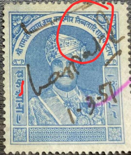
A Postal Stamp issued on Maharaja Hari Singh, Read the Title
Aksai Chin dispute
After the East India Company defeated the Sikh Empire, by Treaty of Amritsar in 1846, the British recognized Gulab Singh, as Maharaja of J&K. Since Gulab Singh had already accepted British paramountcy, the border between Kashmir and Tibet became a matter of negotiation between the British and the Chinese. Within three months of the Treaty of Amritsar, the British constituted a commission to delineate the Eastern boundaries of J&K with Tibet. The British had accordingly asked Maharaja to depute two intelligent officers to work with the officers of the boundary commission. The two boundary commissions of 1846 and 1847 failed to get the cooperation of Chinese officials. The commission clearly placed Chang Chenmo valley well within Ladakh and Lanak La at the eastern extremity as part of Kashmir.
The survey work in Kashmir to determine India’s boundary began in 1855, and WH Johnson, a civilian sub-assistant to Major Montgomery, was assigned the task to survey the North Eastern Ladakh. He remained in Ladakh in 1865, at a time when the Chinese rule over Xinjiang had totally collapsed and a new state of Kashgaria had emerged. However, by 1877, China had reconquered Kashgaria, which was afflicted by frequent internecine wars. Initially, after the conquest of Kashgar, the Chinese treated Kunlun Mountains as their Southern boundary, but subsequently, moved further southward. In 1890, Captain Younghusband, who had gone to Pamirs, was told that Karakoram mountains constituted China’s Southern boundary. To further assert their claim, Chinese unilaterally established boundary markets at Karakoram Pass in 1892; however, it was not objected to by the British. Keith Johnston’s Atlas of 1894 clearly showed Aksai Chin within India. This showed the boundary of Ladakh as running along Kunlun Mountains to a point East of 80-degree East and was similar to Johnson’s position. However, in 1896, there was some protest from Chinese authorities on the depiction of Aksai Chin as part of Kashmir.
How Chushul has come into focus in the India-China standoff
The Chushul sub-sector lies south of Pangong Tso in eastern Ladakh. Situated at a height of over 13,000 feet close to the LAC, the Chushul Valley has a vital airstrip that played an important role even during 1962 War with China. When after the initial attacks, including on the Galwan valley by the Chinese in October 1962, the PLA troops prepared to attack Chushul airfield and the valley to get direct access to Leh. However, just before the attacks were launched, the area was reinforced by the 114 Brigade in Nov 1962, which also had under its command two troops of armour and some artillery.
And today, even though, the harsh winter which is already approaching and lasts for eight months of the year poses a big challenge making it difficult for the troops to dig in and make shelters on the ridgeline as the temperature falls to minus 30 degrees Celsius, and there are frequent snowstorms, as the Defence Minister Rajnath Singh said in the Lok Sabha yesterday, "Indian Army is ready to deal with any situation", and when it comes to safeguarding our territories nothing can stop the brave warriors.